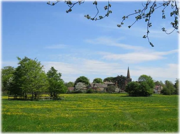
 Shellingford lies about 3 miles south-east of Faringdon on a turning towards Fernham off the road to Wantage. The 2011 Census recorded the parish’s population as 173. The village lies along a tributary to the River Ock, which is the brook that starts beside Park Road in Faringdon and used to feed the old Faringdon Swimming Bath opposite Oriel Cottages. The actual ford that gives the village its name was presumably a crossing-place on it, although there are a lot of fords in Shellingford.
The earliest written evidence of Shellingford as an ecclesiastical district, comes from the Anglo-Saxon Charter of 931 CE bestowed to Abingdon Abbey by King Æthelstan (924-939 CE).3 It was recorded in the charter as Scaringaford (pronounced Sharingaford). The name was possibly from the OE/Anglo-Saxon ‘scear’, meaning ‘shear or ploughshare’, but this may have been a personal name as ‘inga’ means ‘people of’. Then ‘ford’ meaning at a river or stream where crossing was possible. Since then nobody seems to have been able to spell the name consistently. Later records spell the name as Serengeford (Domesday Book 1086), Salingeford, Schalingeford, Shallingford, Sallingford, Schillingford, Shillingworth, and Shillingford. And finally, the latest spelling of Shellingford was decided to avoid confusion with the village of Shillingford near Wallingford on the other side of Oxfordshire.2
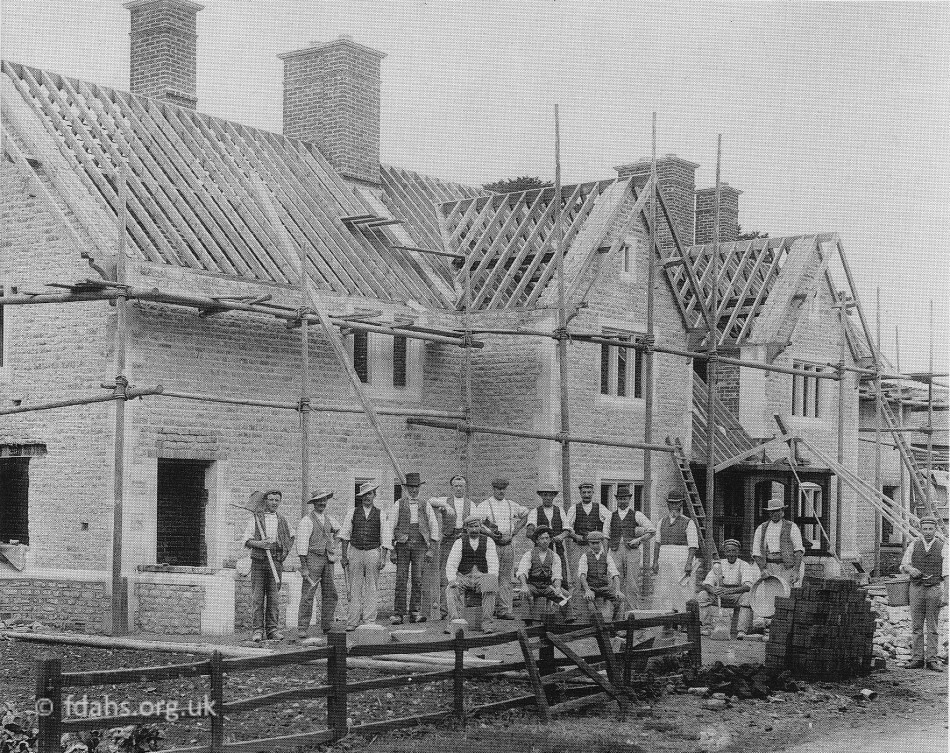 < In the early 1900s, the Henderson family of Kitemore House replaced some old cottages in Church Street with these new houses. There were twelve houses altogether built in blocks of 3, 4, 3 and 2. The stone was quarried from Bowling Alley Copse, The Slade, Shellingford.
 > Looking up Church Street in 1910. The same houses shown from the other direction in the previous photograph are now completed.
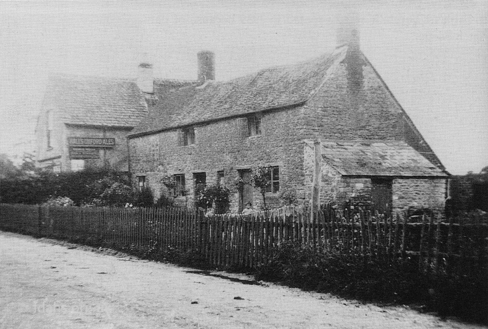
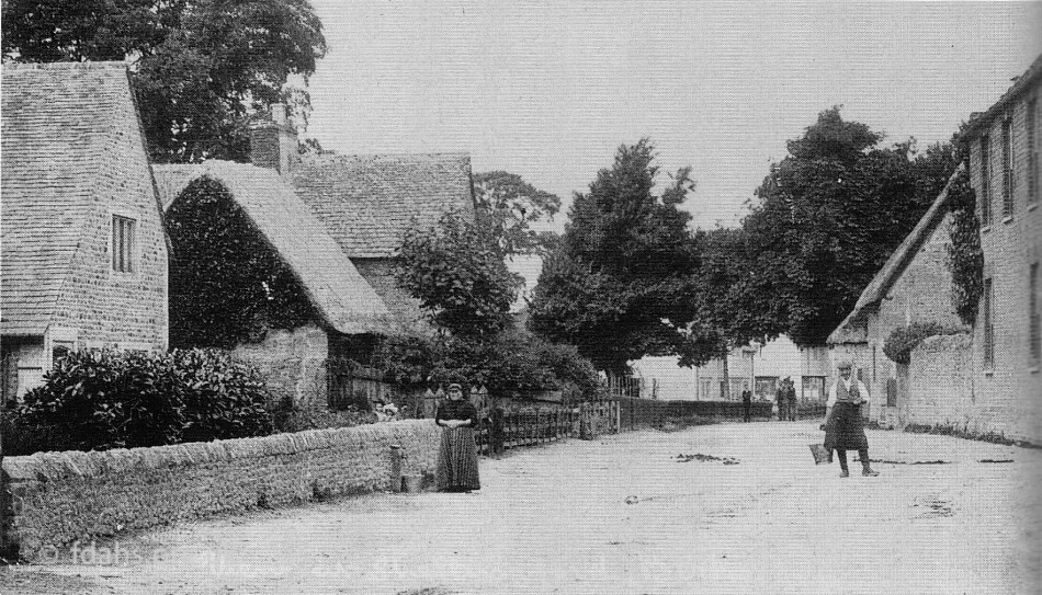 < Looking down Church Street. Notice the lady drawing water at the standpipe on the left. The old cottage next to the Post Office no longer exists. On 26 January 1991, retired farmer Cecil David Gantlett died at Orchard Cottage in Shellingford. Mr Gantlett had for many years farmed at Church Farm house, on the right in this photo. At this time, the farm was occupied by the Maidment family who came from Somerset. By 1911 Walter Maidment had retired and handed over the farm to his son Charles. After the Maidments, the farm passed to Mr Reginald Gantlett from Water Eaton in Wiltshire then to his son (Cecil) David.
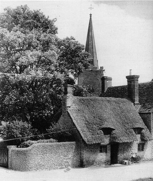 > A 1952 view of the Reading Room, formerly a cottage used as a mens’ meeting room, later used as a dinner room for the schoolchildren. It was pulled down and the area used to make a drive-in access to Church Cottage. In the background is the spire of the Church, the top of which was replaced with one made of fibre glass, when it became unsafe.
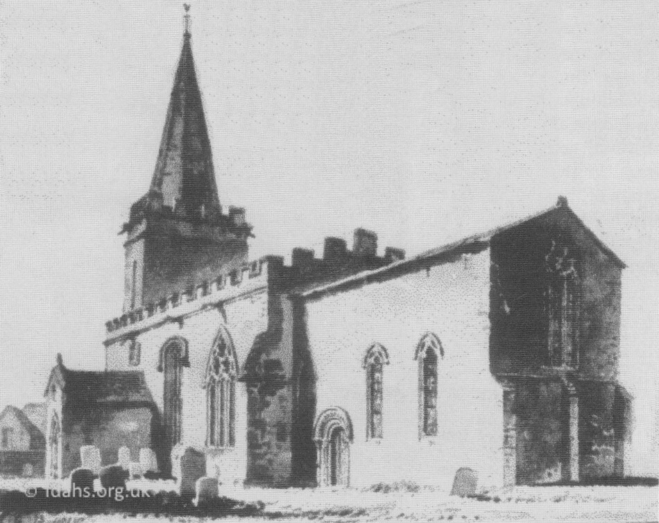 < One of the only buildings from the 1100s surviving intact within the parish today, is the Norman church of St Faith. The original walls of the church are mainly built of coursed and uncoursed limestone rubble, with limestone ashlar dressings. The square tower is late 12th and 13th Century, built in two stages. The spire, with two-light belfry openings, was constructed in 1625 but it eventually fell down and was rebuilt in 1852.3 The church had to be re-roofed in 1939 because of damage caused by the deathwatch beetle.
 < c1901 The pupils of Shellingford School
 > This cottage was occupied by Mr and Mrs George Mitchell until 1932 when they moved to 4 Church Street. George was a shoemaker and repairer and carried on his trade in part of the cottage. This building was eventually condemned and pulled down.

The marriage on August 6th 1907 of Gertrude Pill and Alfred Potter at 7 Church Street.
Left to right, back row: Ernest Pill; George Pill; Henry Pill; ?? Stock; Thomas Pill; W. Potter, best man; Fred Pill; Jack Pill. Middle row: Peggy Pill (George’s wife); Florrie Pill; Annie Stock, née Pill; Elizabeth (Lizzie) Pill; Louie Pill, née Shepherd (Fred’s wife); Rosetta Pill (Jack’s wife); husband of bridegroom’s sister. Front Row: Bessie Pill (Ernest’s wife); Ellen Pill, née Stallard (great grandmother); Alfred Potter (bridegroom); Gertrude Pill (bride); George Pill (great grandfather); Beatrice Pill; bridegroom’s sister (Miss Potter?); William Pill jnr and Ernest Pill jnr (children of Ernest and Bessie).
Kitemore House
The house was built to the north of the village in 1867 by a local firm for Thomas Mills Goodlake as a replacement for Shellingford Manor. The Elizabethan manor house, which stood next to the parish church, was then demolished.
 Kitemore House was the home of Alexander Henderson (1850-1934), the first Lord Faringdon’s eldest son Harold Greenwood Henderson (1875-1922) and his wife Lady Violet Charlotte Henderson (1879-1956)
During World War I, a Red Cross Hospital was set up here in the home of Lady Henderson, where she and four nurses cared for over 242 wounded ‘inmates’ (photo). More on the Red Cross Hospital…
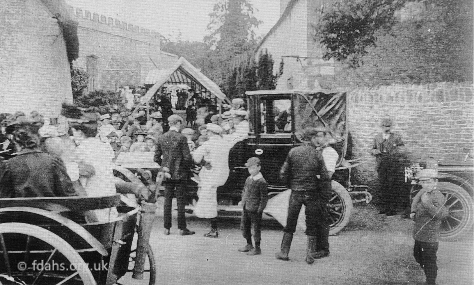 Spectators to a Society Wedding from Kitemore House in 1907. The Green family are in the pony trap on the left.
Early History of Shellingford 3
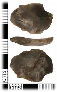
Stone Age (2,600,000 – 3,300 BCE) peoples are known to have been present in the general area, as evidenced by the square-banked enclosure situated to the east of nearby Baulking. This included a standing stone originally in the centre, which may have functioned as a local ritual centre. Various stone tools such as flint axes, scrapers and arrowheads have also been found in the local area. A small number of worked flints, pottery sherds and scatter have been found within Shellingford parish boundaries. Because hunter-gatherers were often mobile, their homes would have been temporary structures with little evidence remaining today.
More permanent settlements began to appear here as pastoral and arable farming developed during the Bronze Age (3,300 – 1,200 BCE) and onwards. During this time, settlements were established at Hatford, Baulking, Stanford in the Vale, Faringdon, Fernham and elsewhere. Presently, there is no evidence of Bronze Age housing in Shellingford. Although, lithic scatter has been found at Shellingford Quarry, including 239 sherds of pottery and 15 flints. The soil in the area of Shellingford today is mainly stone brash/clay, making it particularly useful for mixed arable and grazing. The relative flatness of the area around the River Ock has often resulted in localized flooding, with marshy ground prevailing in wet periods and added fertility to the soil. The word Ock is Iron Age in origin and is believed to have come from the word for ‘salmon’, suggesting the river once teemed with life. Evidence of several fish ponds has been found in and around the village.
During the Iron Age (800 BCE – 410 CE), Shellingford was located on the borders of three Celtic tribes, the Dobunni, the Atrebates and the Belgae. Hill forts are a well-known feature in this area but any information for Iron Age activity within the parish boundaries is sparse. Remnants of a number of small fields bounded by ditches or ridges together with some circular features that were possibly round houses are indicative of past settlement.
Roman Era (43 – 410 CE). A number of Roman coins and fragments of what appear to be roof tiles and brick from a hypocaust system, have been found within parish boundaries to the north of Holywell Brook, suggestive of the presence of a farmstead or villa of unknown importance and size. A Roman coin was found in the land surrounding Shellingford House (the original site of the rectory in the later Middle Ages). Agricultural activity implies the presence of a small settlement comprised of farm estate workers. Shellingford, on current evidence, appears to remain a small, outlying settlement in this period when compared to the neighbouring areas of Hatford, Faringdon, and Stanford in the Vale, where many more artefacts and buildings have been confirmed by archaeology.
Early Medieval Era (410 – 1066 CE) was largely dominated by Anglo-Saxon, Norse & Dane occupation. Shellingford, being south of the Thames, would have originally been a part of West Sexena or Wessex. As the separate kingdoms united to form one nation, England was eventually divided into districts, some called ‘scirs’ (pronounced ‘shires’), each administered by a ‘shire reeve’ or ‘sheriff’. The name Wessex became redundant and Shellingford became a part of Berkshire and in 931 CE became the property of Abingdon Abbey.
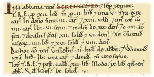
Late Medieval Era (1066 – 1485 CE). Following the Norman Conquest, a period of feudalism with a strong Norman flavour was overlaid on Anglo-Saxon society. Norman loyalists replaced many Saxon earls, bishops and abbots. Shellingford (spelt Serengeford) in the Domesday Survey of 1086, was listed as being part of the hundred of Gainfield in Berkshire. There were twenty-one households calculated by male heads, with the total population estimated to have been five times that figure (approximately 105 men, women and children). Shellingford had one mill valued at two shillings and five pence – this was not large compared to others in the wider area. Shellingford’s mill was in existence for at least six hundred years, the location likely changing through time. Dairy farming must have been an extremely important aspect of Shellingford life – the Abingdon Abbey Chronicals (1100-1119) includes a list of estates which were to produce cheese and notes Shellingford first, providing the greatest amount, thirty weys (30×175 lb), and in addition Robert of Bretteville’s farm (also in Shellingford), six weys.
References:
- Photos and text scanned directly from The Changing Faces of Faringdon and Surrounding Villages – Book 1 p113-120 by Rosemary Church, Jim Brown, Millie Bryan and Beryl Newman. Robert Boyd Publications 1999 – now out of print. Other photos were scanned from society archives.
- The English Place-Name Society – https://epns.nottingham.ac.uk/browse/Berkshire/Shellingford/53282e4fb47fc407ba001b95-Shellingford also useful search page – https://epns.nottingham.ac.uk/search
- Shellingford: A Parish History. Part 1: Prehistory to 1485. By Mary P. Thompson Vogwell MA.