Geology
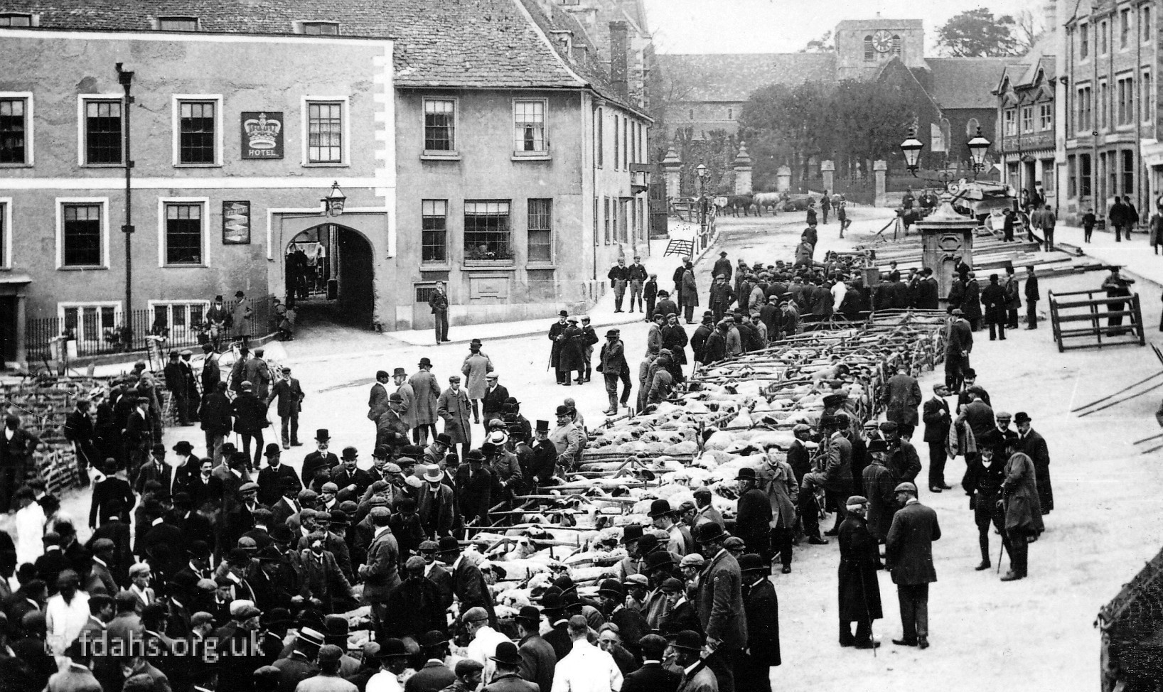
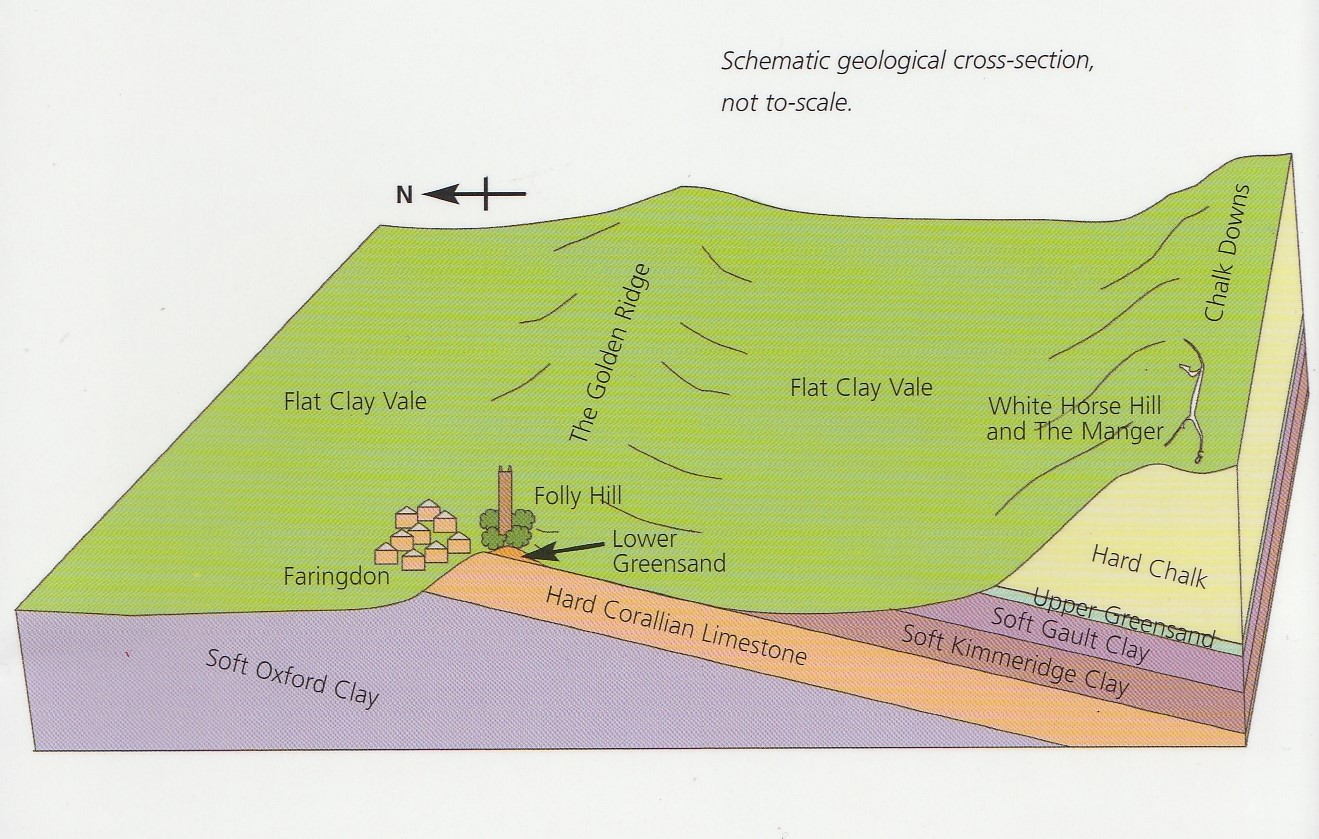 Faringdon is situated near the southern limit of a low ridge of honey coloured limestone (commonly known as the Golden or Corallian Ridge) which extends from Wheatley, on the outskirts of Oxford, towards Swindon. The town itself ls situated in the only valley of any significance cut into the northern side of the Golden Ridge which was eroded by a stream flowing northward into the Thames. The stream was fed by water issuing from the Faringdon Sponge Gravels, an excellent aquifer, which rest on the Corallian rocks above the town, and was probably augmented by melt waters during the last ice age. What remains of the old Faringdon Brook is now mostly covered over and passes under the road in ‘The Narrows’ between the Market Place and Corn Market, and then into a lake that was created within the grounds of Faringdon House.
The Corallian Ridge was an ancient coral reef formed about 150-200 million years ago during the time known as the Jurassic Period when this part of England was situated at the latitude of the present day Mediterranean. Much of the town is actually built of these limestone rocks and sometimes can be seen in the house walls.
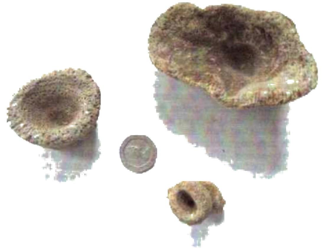
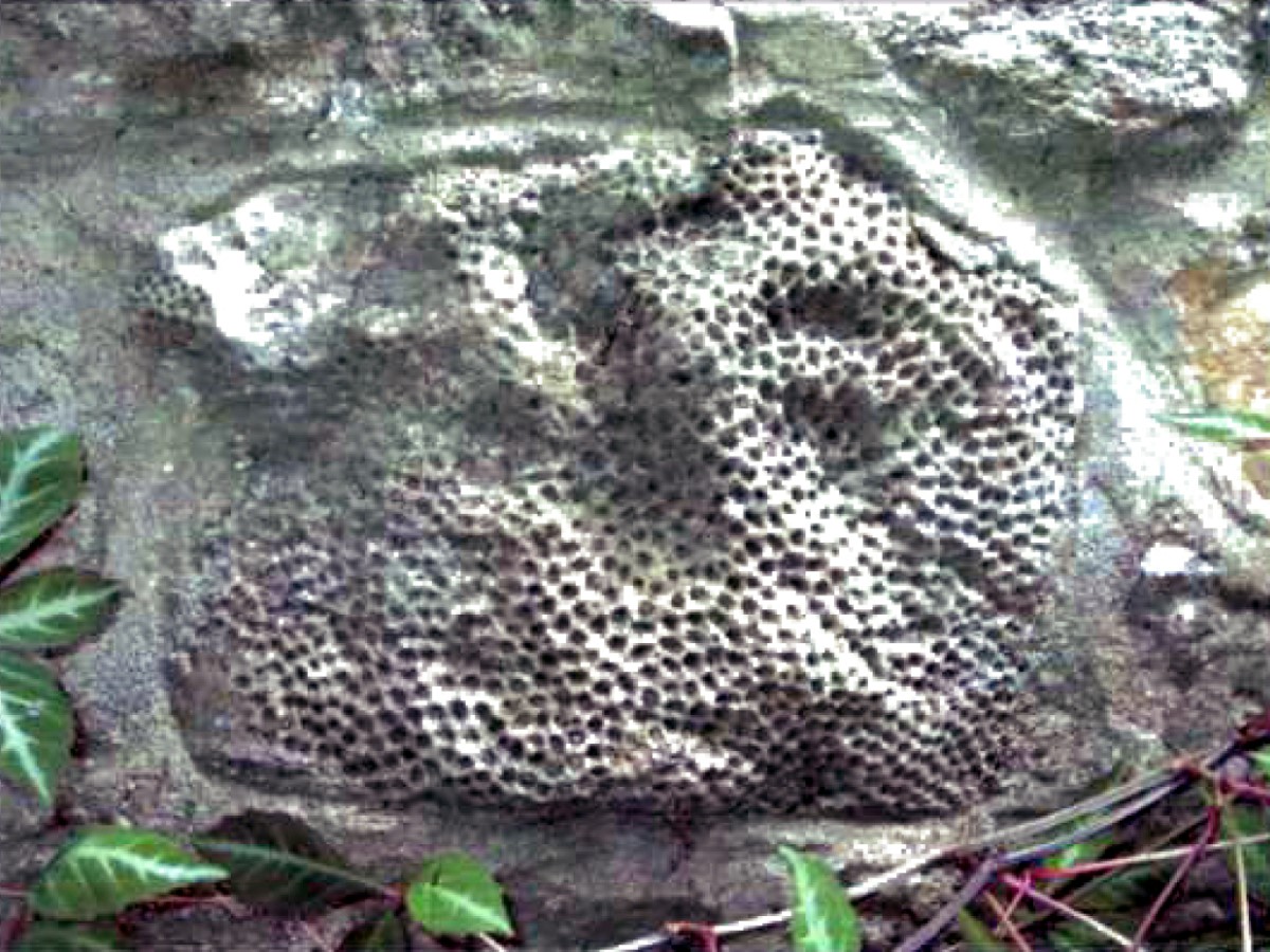
After the coral reef (on which much of Faringdon is now built) emerged from beneath the sea for about 30 million years it was then submerged again at the beginning of the following Cretaceous Period. The sand and gravel deposited during this time on the new sea floor around 115 million years ago is unique to Faringdon and famous for the many fossils it yields. The Faringdon Sponge Gravel is packed full of fossil sponges, and other fossils such as belemnites, shellfish, ammonites, echinoids (sea urchins), brachiopods and bryozoa. Some Jurassic dinosaur and plesiosaur remains have also be found.
Are the Faringdon Sponge Gravels so named for their spongy water-retaining properties or for their content of fossilised creatures called sponges?
The large deposits of sand, gravel, and special clays like Fuller’s Earth that were laid down on the sea bed during the Cretaceous Period have brought about much quarrying around here during our more recent history. The Faringdon Sponge Gravel makes excellent building sand and is also used for gravel paths … Quarrying In & Around Faringdon.
Read more … Faringdon Rocks by Norman Snelling (pdf)
More archaeology … Coles Pits | Society Exhibitions | Local Detectorists
Oxfordshire Geology Trust website – Faringdon Trail Guide
Iron Age (800 BCE – 410 CE) 3
Baulking Hill – Iron Age pottery, scattered over a large area, indicates the presence of continued and expanded settlement until the end of the Roman Administration.
Charney Bassett – The presence of an Iron Age lowland fort has been identified – Cherbury Camp. On excavation, a hut circle and pits were discovered with outer limestone blocks visible. The entrance was cobbled. Specific finds include pottery pieces and a gold coin of Cunobelinus, indicative of settlement and trading throughout the Iron Age. Wheel ruts were found on a metalled track leading to the fort, highlight wheeled vehicles were used for transportation. The camp is unusual since it is a lowland fort. Archaeological investigation of the surrounding area, however, has revealed the area was wet and marshy, effectively creating a more defensible island.
Faringdon – An Iron Age rectangular enclosure and ring ditch unearthed through archaeological investigation, with buildings, pits (including for ritual purposes), coins, and an example of continental ‘La Tène’ pottery. The presence of this finely made pottery indicates people were trading internationally.
Iron jewellery, typical of the Oxfordshire/Berkshire border found at a quarry on the A420 near Wicklesham Farm. The jewellery indicates the established utilization of Iron goods for decorative purposes, which is, in turn, suggestive of wealth and prosperity.
Fernham/Little Coxwell Border – A univillate and defensive hill fort is present at Ringdale Manor, extending to an area of twelve acres. Iron Age and Roman pottery was unearthed, indicative of extended settlement.
Hatford – A Middle Iron Age to Roman settlement excavated at Manor House Farm, including building, enclosure, inhumation, pits, settlement and track-way and field systems. Two brooches, beads, a loom weight and weaving comb for cloth making purposes, possibly at a commercial scale were unearthed. This technology was not new, having been adopted from at least the late Neolithic. Another area of settlement at Hatford Sandpit was also discovered with evidence of at least four burials, a part of a Roman building, and Belgic material, all indicative of international trade.
Stanford in the Vale (Western Edge) – A double-ditched drove way with adjoining rectangular enclosure, visible on aerial photographs, found in the area surrounding Bowling Green and Chinham Farms, also a small causewayed ring ditch, and two ditches of Iron Age to Roman date. Iron Age pottery and a wooden palisade were also uncovered. To the north of the area, a substantial Middle Iron Age to Roman settlement.
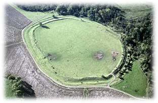
Uffington/Woolstone – A D-shaped hill-fort over eight acres with sarsens and timbers and two phases of rampart construction has been unearthed. Dragon Hill exhibits strong evidence of Iron Age use as well as later Roman activity. Uffington Castle was an early Iron Age fort located on the top of the hill above the White Horse and later occupied by the Romans. More …
Roman Occupation (43 – 418 CE) 3
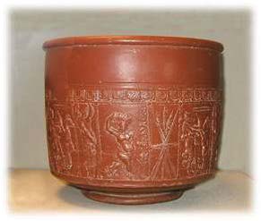
Baulking – A large amount of Roman pottery has been uncovered over a wide area, including Samian Ware (high status Roman pottery produced in mainland Europe) from the 1st Century. All are indicative of settlement and international trading links.
Faringdon – A Roman settlement discovered adjacent to Park Road. The settlement included a ditch, enclosure, pits and postholes. Two Roman coins, a Constantius Quarter Follis, Denarius of Alexander, now in Newbury Museum, and a Roman brass coin now too corroded to identify. The continuation of a previous Iron Age settlement into the Roman Era, featuring a Roman Shrine, inhumation, Roman ditch and Roman corn-drying kiln was unearthed on the Coxwell Road.
Fernham and Little Coxwell Border – The continued use of an Iron Age univallate defensive hill fort by Romans/Romano British is evidenced at Ringdale Manor. Roman pottery and a Roman Field system were identified on the east edge of the camp.
Hatford – Prehistoric track ways were adapted, and the Bronze to Iron Age settlement at Manor House Farm continued into the Roman Era. An early Iron Age settlement at Hatford Sandpit also continued, where Belgic material and part of a Roman building were identified. A Romano British settlement was also identified to the northeast of the village. Surface scatter was found over a large area.
Stanford in the Vale – A significant Roman settlement was found within the centre of the village, covering at least six hectares with a possible small market centred beside the Ock. Three Roman sherds were discovered in a garden adjacent to the manor house.
Stanford in the Vale (Western Edge) – A settlement beside Frogmore Brook, possibly a large rural village with shrine, was identified east of Bowling Green Farm. Finds included a Roman axe, bowls, brooches, coins, figurine, intaglio, knife, ring, seal box, pottery sherds, tweezers and urn – all indicative of a sizeable and wealthy settlement. Roman building material and distinct building platforms and lines of walls were excavated, where a large quantity of 2nd to 4th century pottery was recovered. A Roman Villa situated at (map reference) SU 325 952, indicates activity continued into the early Medieval Era. A Roman-British spindle whorl now in the Treacher Collection at Oxford University was also discovered.
Woolstone – A Romano-British villa featuring a tessellated corridor and pavement with the addition of buildings for bathing was unearthed.
References:
- Faringdon Rocks or Rock Around The Town: A guide to the geology around Faringdon and its influence on the character of the town by N.J.Snelling. (Norman Snelling graduated in geology at the University of Manchester in 1951 and worked in various official capacities in locations all over the world before coming to live in Faringdon.)
- Faringdon Trail: A leaflet published by Oxfordhire Geology Trust.
- Shellingford: A Parish History. Part 1: Prehistory to 1485. By Mary P. Thompson Vogwell MA.