The market town of Faringdon is perched on a golden limestone ridge at the edge of the Vale of the White Horse overlooking the valley of the River Thames with views of the Cotswold Hills to the north and the North Downs to the south.

Early History – Recent discoveries in the Faringdon area have found evidence of occupation by Iron Age people and the Romans. The Bronze Age ‘White Horse’ and Iron Age Hill Fort on the ancient Ridgeway track above Uffington and the Neolithic chambered long barrow at Wayland’s Smithy above Woolstone are the most famous of all. The evidence for Saxon occupation is very sparse as Saxon pottery does not last well in the soil in this area, but excavations at Lechlade and Shrivenham have revealed large, wealthy Saxon communities. The River Thames formed the border of the Kingdom of Wessex with the Kingdom of Mercia to the north so the area must have been involved in disputes over territory. The Saxon kings of Wessex may have located a palace or hall here, probably near the church and possibly on the site of the later Faringdon House or the Salutation Hotel, but there is no confirmed evidence of this. We do know that Alfred the Great was born in Wantage in around 848 CE and prior to the Norman Conquest by William the Conqueror in 1066, the defeated Saxon, by then the English king, Harold owned the manor of Faringdon.
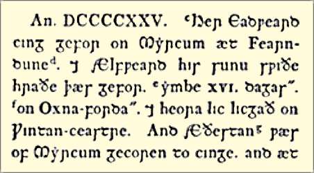 925 – The Saxon Chronicles – This town of Faringdon is not the one mentioned in the Saxon Chronicles as once believed and is not where Edward the Elder, son of Alfred the Great, died. Another town, Farndon-on-Dee in Cheshire, which was then called ‘Fearndune‘ or ‘Færndun‘ meaning literally ‘fern hill or hill-fort’ does however appear. The letter ‘r’ was very firmly pronounced, which lead to the development of various spellings over the years. More about Faringdon’s name…
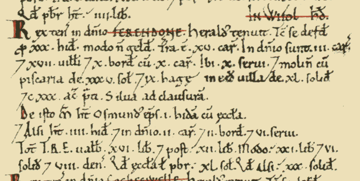 1086 – The Domesday Book – Ferendone (in the hundred of Wyfolhd* and county of Berchescire**) was recorded with 47 households – 17 villagers, 12 smallholders, 16 slaves, 130 acres meadow, 1 mill, 1 fishery, 1 church.
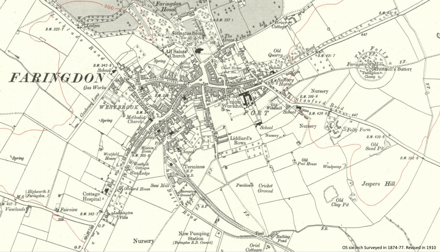
* The hundred (administrative district) of Wyfold consisted of Buscot, [Great] Faringdon, Eaton [Hastings], [Great] Coxwell, and [Little] Coxwell.
** Berchescire (1086 CE) derived from the earlier Bearrocscir (839 CE) – Bearroc, a Celtic word meaning “hilly place” plus Anglo-Saxon ‘scire‘, pronounced ‘shire’. Faringdon was transferred from the county of Berkshire to Oxfordshire (Oxenefordscire 1086 CE) in 1974.
1145 – Queen Matilda’s Fort – King Stephen attacked and captured Queen Matilda’s fort on what is now called Folly Hill. Stephen spent much of his reign in constant battle with his cousin and rival, Matilda, who was daughter of the previous king, Henry I. This fort, which was doubtless only an earthwork with timber defences, was probably destroyed shortly afterwards. These battles, actually the first civil war in Britain were known as ‘The Anarchy’. More about ‘The Anarchy’…
1180 – All Saints Church – the nave, the oldest existing part was built on the site of earlier buildings of the Late Saxon and Early Norman periods.
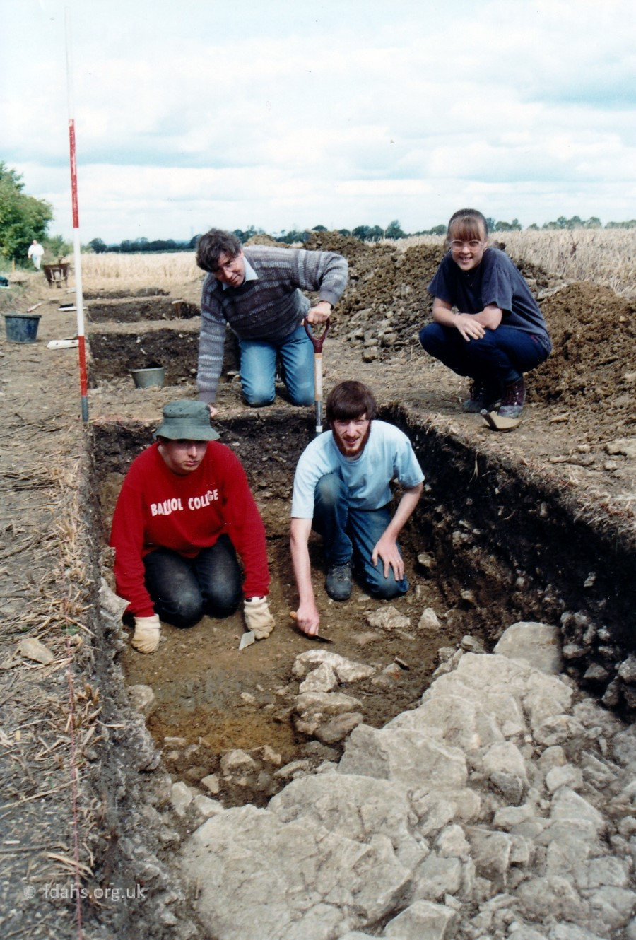
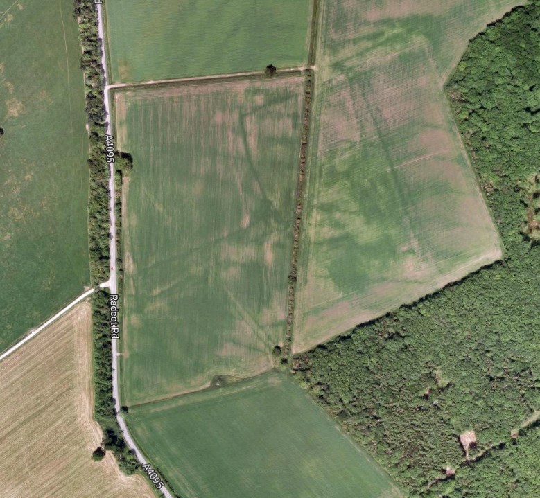 1203 – Cistercian Monastery – King John gave the Cistercian Order the manor, including a piece of land at Wyke (location on map), on which to build a monastery. The monks erected some buildings, the remains of which were re-discovered in 1992. However the monks didn’t stay for long as they preferred a site that was more remote from centres of population. The Cistercians moved to Beaulieu, leaving Faringdon and Great Coxwell to become granges for the collection of agricultural produce. The produce was sold and the proceeds sent to Beaulieu. The Great Barn at Great Coxwell dates from this time and it is likely that a similar building was extant at Faringdon. Beaulieu Abbey continued to hold land in Faringdon until the dissolution of the monasteries in the 16th century. Other large, local landowners have been some of the Oxford colleges. Oriel College owned Wadley, Littleworth, Wicklesham and parts of Faringdon. Brasenose College owned parts of Port and Westbrook in Faringdon.
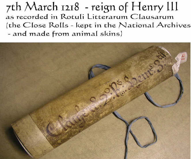
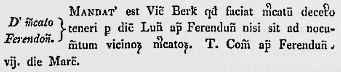
1218 – Faringdon’s Market Charter – On 7th March 1218 during the reign of Henry III, the Shire of Berkshire was ordered to ensure that the market in Ferendun or Ferendon be henceforth held on Mondays so long as this does not cause a nuisance to other markets in the vicinity. This was probably an order to change the day of an existing market, which was possibly on Sundays. It was later changed on 18th February 1313 during the reign of Edward II by another royal charter to Tuesdays. More about Faringdon Market…

1269/70 – Royal Visit – King Henry III and his wife Queen Eleanor of Provence, with the Lord Edward and his wife Eleanor of Castile, came to Faringdon between Michaelmas (29 September) 1269 and Michaelmas 1270. Henry, eldest son of King John, died two years later in 1272, when he was succeeded by his son Edward I.
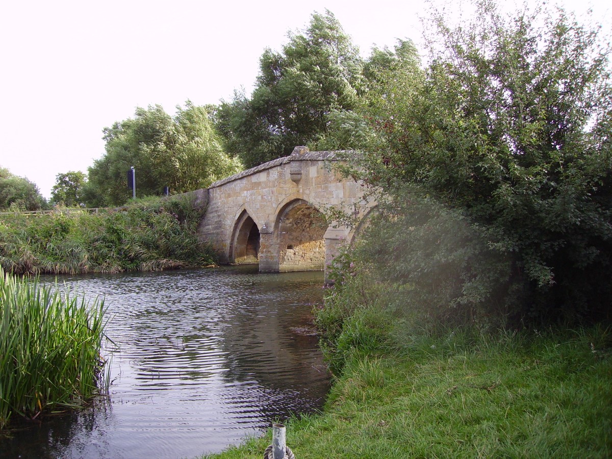
 1387 – Battle of Radcot Bridge – was fought and won against troops loyal to the young, wildly extravagant and increasingly unpopular Richard II. Radcot Bridge, mentioned in the 1086 Domesday Book and said to be the oldest existing bridge over the River Thames was then on the boundary between Oxfordshire and Berkshire. This is the first large bridge you come to from Faringdon. There are 2 more bridges as the river splits into three channels at this point. More about Radcot Bridge…
One contrary record suggests that the royalist Robert de Vere attempted to escape across the bridge, but found it had been broken down and eventually was forced to swim with his horse across the stream to the imminent peril of his life. His armour was found and he was presumed drowned, though he later turned up in France. The bridge was rebuilt a few years later.
1455-1485 – Wars of the Roses – Faringdon opted for the House of Lancaster, associated with a red rose – as seen in a stained-glass window in the lower bar of the Crown Hotel. The opposing side in this civil war for control of the throne of England was the House of York, whose symbol was a white rose. Radcot Bridge was again severely damaged during the battles and was later rebuilt as it appears today.
 1551 – The Port Well & Faringdon Brook – The Port Well, given to the town by Sir Henry Unton, Lord of the Manor in the 16th century was the towns only piped water supply and later used for horses and cattle. It still stands out the front of the Pump House that was built above the spring. Faringdon was originally crossed by a brook which formerly divided Port, the borough on the east from Westbrook, the manorial settlement in the west. In 1551 it was recorded that the brook was crossed by a ford close to which was a smithy. By 1848, the brook had been piped and now runs under the shop at 1 Cornmarket and the road, before draining into the lake at Faringdon House in the Thames Valley to the north. The brook once existed in the area behind the shop between Southampton Street and Bromsgrove, largely now the town car park, and was used by a leather tannery run by Bailey Bros. The new roads called Portway and Westbrook further to the south mark the upper reaches of this brook which originated in the area of the former railway station in Park Road. The new road Hart Avenue is a ‘flyover’ of the valley of the old brook in order to join Ferndale Street to Bromsgrove and help alleviate traffic flow away from the town centre. More about the Pump House, Theatre & Portwell…
1628 – Meteorite Landing Nearby – At about 6 pm on Wednesday 9th April 1628 a shooting star passed low over the Coxwell and Fernham villages in the direction towards Wantage. It was quoted at the time that there was a “hideous rumbling in the air; and presently after followed a strange and fearful peal of thunder”. The meteorite broke in the fall and a stone landed 3 miles away from Faringdon on Baulking Green, another landed at Challow. The largest piece was recorded at 19.5lb (about 9kg), which would have been basically a large fist-sized cannon ball travelling at over 400 mph when it hit the ground.12
1635 – London to Bath Courier Service – Mud-spattered post-boy riders changed their horses and stopped for refreshment at The Crown.
 1642-1651 – English Civil War – between Parliamentarians and Royalists, Faringdon became a strongly defended garrison town under the Royalist’s Commander Colonel Lisle protecting King Charles and his forces at Oxford. There were several small skirmishes in the area and in 1644 Oliver Cromwell based an army on the slopes of Folly Hill and led an attack on Faringdon House, where the garrison was ensconced, but failed to subdue it. The garrison finally surrendered to the Parliamentarian forces on June 24th 1646, being one of the last places to do so and they left Faringdon the second most destroyed town in England. During the war the church and the town had been extensively damaged and in 1648 the townsfolk asked Parliament for compensation, the damage, which included the lost church tower being assessed at £56,976 4s, but this was refused. More about the Civil War…
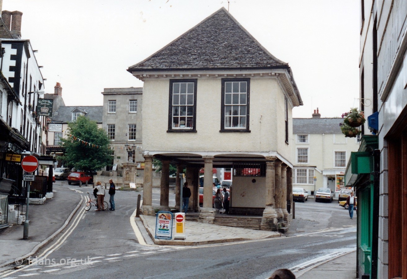
 1650-60 – The Market (Town) Hall was built – It was a hive of activity on market days when farmers’ wives would sell their surplus eggs, butter and cheeses under the shelter of the meeting room above. During its long history it also included the town’s first jail, first fire & ambulance station, and first library. More about the Market Hall…
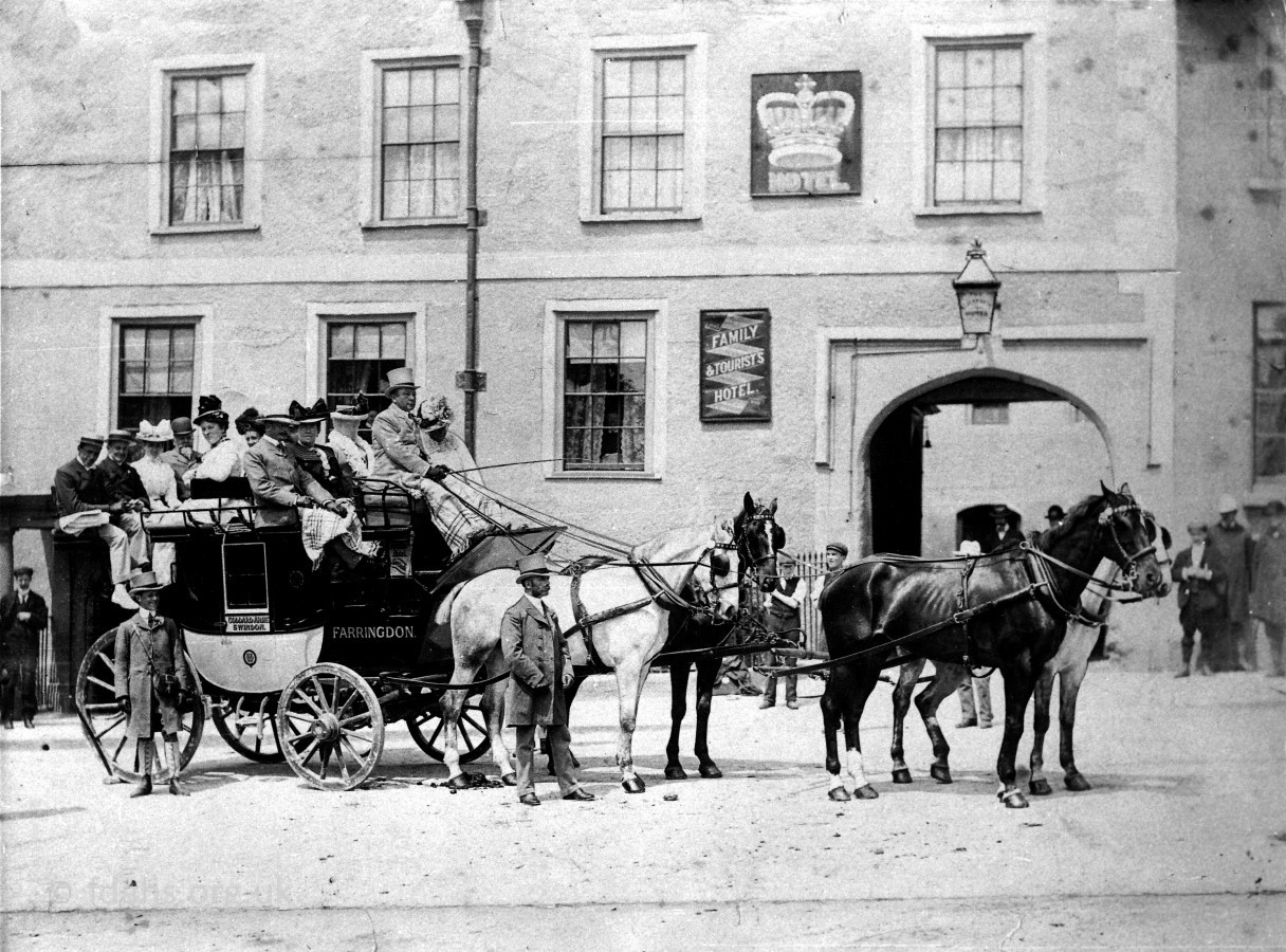
1700s-1800s – Five-way Road Junction – Faringdon was situated on an important and ancient five-way road junction receiving traffic from all over the country. Hence the naming for London Street, Gloucester Street, Marlborough Street and Southampton Street. The latter leads towards what is now the new Health Centre, then Wicklesham Farm and beyond but has mostly remained no more than a simple track or footpath. The Radcot Road provided an important trade route to the north into Oxfordshire and beyond. Faringdon was connected by Turnpike roads to London and Gloucester by 1733 and to Wantage and Wallingford in 1752. Turnpike roads were major highways during the 18th and 19th centuries usually involving a barrier for collection of tolls to pay for their maintenance. By 1813 coaches were passing through Faringdon from the West Country on their way to London every Tuesday, Thursday and Saturday. More about road transport… Many public houses and coaching inns developed as a result. In the 1960s there were about 21 public houses for a population of around 3500. By 2011 the population had doubled and pubs were closing down. There are only 6 pubs left now in 2020. More about Faringdon’s pubs…
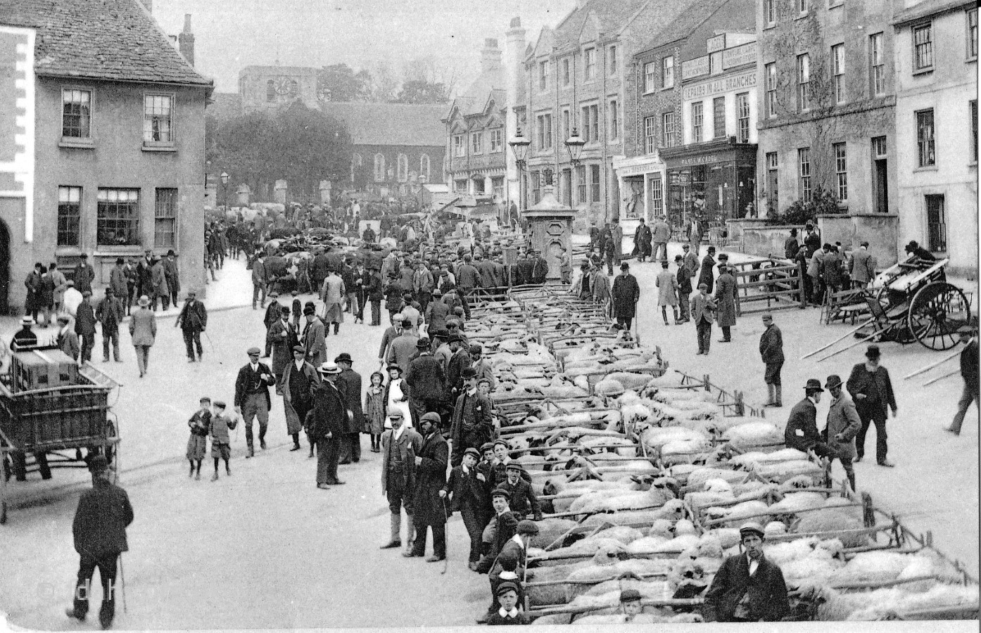
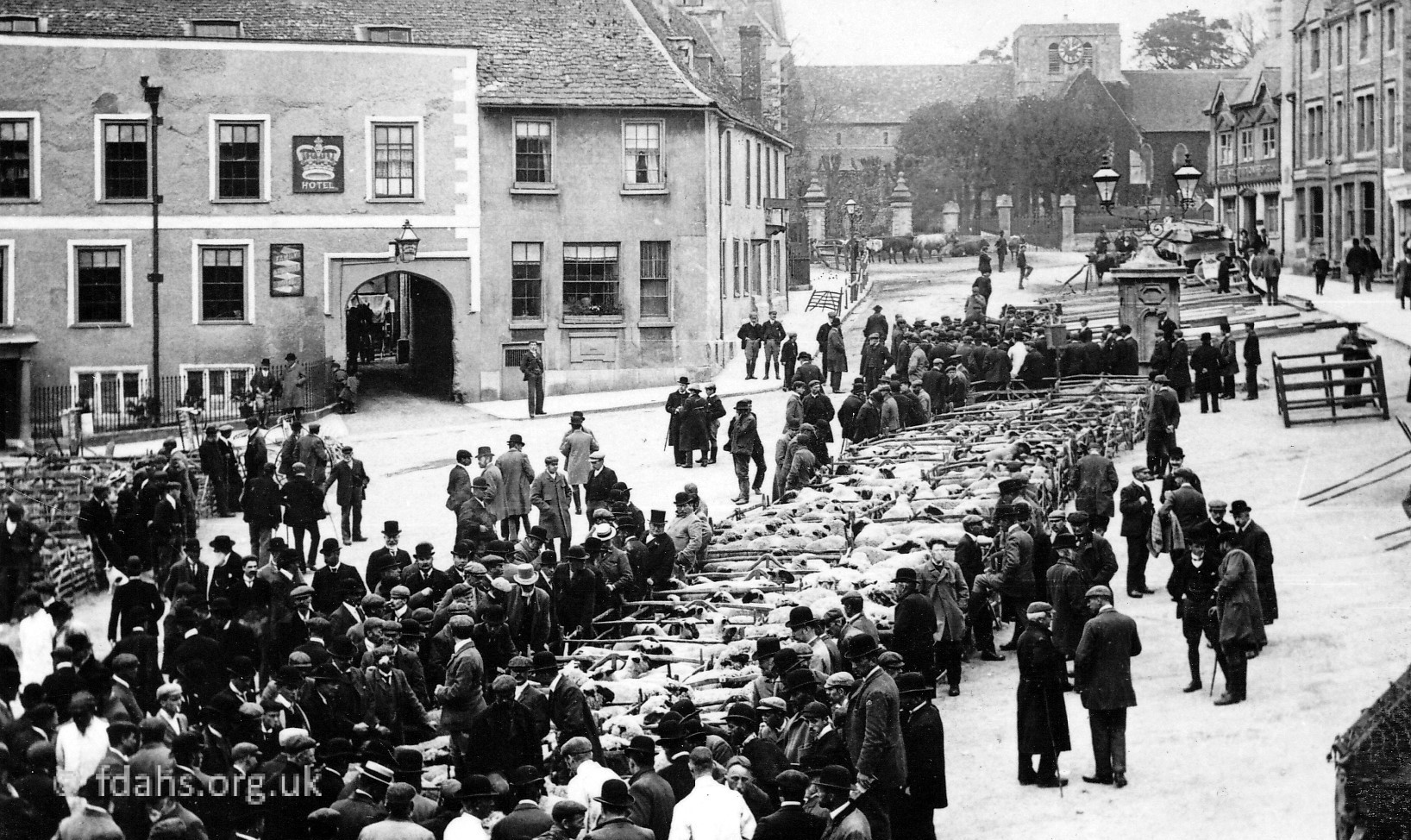
1700s-1800s – A Thriving Market Town – Faringdon’s position led to it becoming a thriving market for the sale of agricultural and animal produce. It was especially known for the sale of cheese and pigs. In the journal of Thomas Baskerville he mentions passing through Faringdon and that ‘a great fair for horses, cattle and other goods, was held here on Whitsun Tuesday and that there were many inns in the town, the chief of which was the Crown.’ In 1813 ‘there was a great quantity of swine fatted in Berkshire and Faringdon slaughters 4,000 pigs for the London and Oxford markets between the beginning of November and the beginning of April’ About 8,000 sides were smoked annually in Faringdon before being sent to market. Edward Loveden’s dairy farm, at Buscot, used its surplus milk to rear the Berkshire black pigs and he sold them as breeding stock throughout the world. More about Faringdon Market… The Market Hall, built in the late 17th or early 18th century, was used to sell butter, eggs and farm produce on market days. More about the Market Hall…
1810 – The Wilts and Berks Canal – linking the Kennet & Avon Canal to the River Thames. It was 52 miles long and was mainly used to carry coal from Somerset, but it also carried stone, salt and agricultural products. It was first proposed in 1793 but it took until 1810 for it to brought right across the Vale to join the Thames at Abingdon. The canal was navigable to the wharf at Longcot by December 1805, then other wharves were built at Uffington, Challow and Wantage.
1835 – Gas-lighting first came to Faringdon – More…
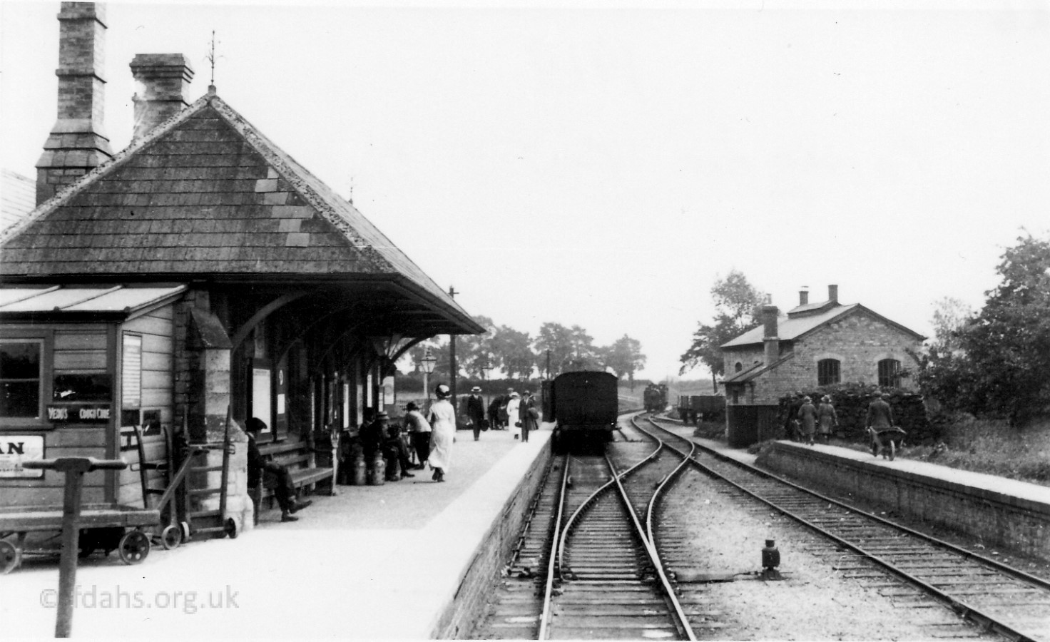 1864 – Faringdon Railway Station – The importance of the roads and canals declined with the coming of the railways, when on 1 June 1864, Faringdon found itself with a railway station at the end of a branch line off the main London to Bristol route. Within 5 years, between 150 and 180 churns of milk a week left the station to join the main line at Uffington. The line was closed almost a hundred years later in 1963 as traffic by road, by now using the well established internal combustion engine on smooth tarmacked surfaces, once again grew in importance. More about the railway…
1911/12 – Electricity first came to Faringdon – More…
1930 – Lord Berners moved to Faringdon House – More…
1936 – Folly Tower built on Folly Hill – More…
1974 – Faringdon was transferred from Berkshire to Oxfordshire
The Local Government Act 1972 instigated changes to the borders of some of the counties of medieval England. On 1st April 1974, Faringdon along with Abingdon, Didcot, Wallingford, Wantage, and other towns in Berkshire south of the River Thames were transferred to the county of Oxfordshire. The county border once along the river (as was the border of ancient Wessex) was moved to just south of The Ridgeway on the Berkshire Downs. (So close to this ancient track in fact that one might wonder why it was not designated as the actual border.)
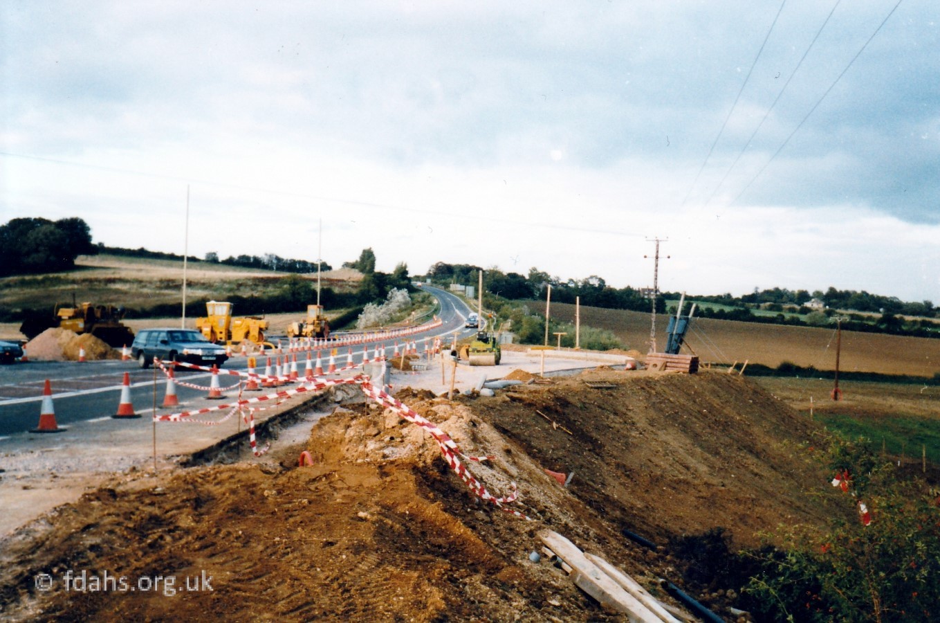 1979 – Faringdon Bypass – Situated on a major route between Oxford and Swindon, Faringdon was bypassed in July 1979. More about Faringdon’s traffic problems…


 2024 – The Northern Lights Over Faringdon – These photos were taken in Faringdon around midnight on 10th May. The display continued into the early hours of the next morning. This must be a first. The lights were even visible in the UK as far south as Kent.
 Population of Great Faringdon Parish:
Faringdon in the 21st century is gradually becoming a major dormitory town for people working in Oxford, Swindon and elsewhere. The 2011 Census recorded the population as 7,121, almost doubled since 1971 and expected to be soon approaching 11,000 following recent extensive housing developments.
1831: 3,033 (cf. pre-railway village of Swindon only 1,742)
1901: 2,900
1911: 3,079
1921: 2,758
1931: 2,702
1951: 3,207 (little changed in 120 years)
1961: 3,398
1971: 3,609
1981: 4,646
1991: 5,235
2001: 6,187
2011: 7,121 (cf. Swindon 182,441)
2021: 8,627
2031: 11,000 projected, following massive housing developments.
| CENSUS | 2001 | 2011 | 2021 |
| Total usual residents: | 6,187 | 7,121 | 8,627 |
| Gender: male / female | 48.9% / 51.1% | 48.7% / 51.3% | 48.3% / 51.7% |
| Aged <18 / 65+: | 23.5% / 14.5% | 22.8% / 16.1% | 22.5% / 18.2% |
| Number of households: | 2,627 | 3,013 | 3,346 |
| Religion: Christian / other / none | 61.4% / 1.5% / 37.1% | 49.7% / 2.2% / 48.1% |
The 2011 Census also provides some further information about the parish:10
| Total usual residents: 7,121 Average age: 39 years Aged under 18: 22.8% Travel to work: 3,672 (51.6%) Travel over 10km: 1,960 (27.5%) |
Number of households: 3013 Households owned: 61.6% Lone-parent households: 5.6% Households with 1+ cars: 84.6% Households with 2+ cars: 42.8% |
References:
- The Gough Map of Great Britain: https://www.goughmap.org/settlements/8052/
- Old Maps Online – A map of the county of Berks – 1762: : https://www.oldmapsonline.org/map/unibern/000992352
- Oxford-Fyfield-Faringdon-Purton Road Strip map by J. Owen & E. Bowen – 1753: https://www.amazon.com/Oxford-Fyfield-Faringdon-Purton-road-strip-OWEN-BOWEN/dp/B019P3CJU6
- National Library of Scotland – Berkshire VIII.SW (includes: Great Coxwell; Great Faringdon; Little Coxwell; Shellingford.): https://maps.nls.uk/view/97772849
- British History Online – Parishes: Great Faringdon: https://www.british-history.ac.uk/vch/berks/vol4/pp489-499
- Open Domesday: https://opendomesday.org/place/SU2895/great-faringdon/
- Wyke monastic grange and section of 18th century turnpike road: https://historicengland.org.uk/listing/the-list/list-entry/1020967
- Faringdon Community Website – Market Charter for Faringdon (pdf): https://www.faringdon.org/uploads/1/4/7/6/14765418/market_charter_1218_and_1313.pdf
- The Changing Faces of Faringdon and Surrounding Villages. Books 1-3. By Rosemary Church, Jim Brown, Millie Bryan and Beryl Newman. Robert Boyd Publications. Now out of print – copies may still be available from Faringdon Tourist Information Centre or by contacting the society.
- NOMIS – Official Census Statistics: https://www.nomisweb.co.uk/reports/localarea?compare=E04008216
- https://www.citypopulation.de/en/uk/southeastengland/wards/vale_of_white_horse/E05012973__faringdon/
- The UK and Ireland Meteorite page – http://www.meteoritehistory.info/UKIRELAND/C17.HTM#hatford
Researched by Ian Lee, November 2018 with extracts from an introduction by Rosemary Church, April 1999.